An Address made by Irvin W. Near at the Centennial of the First Settlement of Hornellsville, on September 25th, 1890.
Mr.Chairman:
The territory now embraced within the limits of the city and town of Hornellsville and the immediate neighborhood, has been claimed by three European governments.
Spain by discovery affirmed by a papal bull. France and England have proclaimed and asserted ownership, by colonization and conquest, and, in the name of their respective monarchs, have occupied it with armed military forces. The tri-color of France and the cross of St. George have floated in its breezes, as an evidence and an admonition of their respective occupation, dominion and sovereignty. The rights of the native Indians, the English claimed, was the right of possession, subject to be acquired by purchase or conquest. The claim of the French was that France was the absolute owner of the soil, that the Indians were their wards, to be governed and cared for as the home government might direct. It has been given and granted by conflicting royal charters, and by sovereign states; has been transferred by treaties solemnized both in Europe and America, and was part of the domain conveyed by the largest sale of land ever made by a government to private individuals.
Forty-two years after the discovery of America by Columbus, Jacques Cartier landed at Hochelaga, now Montreal, on the banks of the river St. Lawrence, erected the cross, and planted the French flag, and setting aside the papal bull of Pope Alexander VI, proclaimed in the name of Jesus and Mary, and of Francis I, of France, that he took possession, in their names, of that river and all its tributaries and lands adjoining both remote and distant. The same claim and right was re-asserted by Champlain, at the founding of Quebec in 1608.
The English under Gosnold had entered Chesapeake Bay in 1607, and the Dutch in the person of Hendrick Hudson, had entered the river that bears his name in 1609. Each claimed the adjacent country for their respective monarchs.
In tracing the advent of our race to this locality, French colonization and occupancy must, of necessity, take precedence.
All that portion of what now constitutes the State of New York, lying westerly and northerly of the boundaries of Oneida county, and the extensions thereof, from and after the arrival of Champlain upon the St. Lawrence, until the conquest and treaty in 1762 – a century and a half – formed a portion of French Canada, or in a more extended geographical designation, New France, and this identical locality was a part of this territory, and was carefully watched, and jealously guarded by the French government. In 1690 Count Frontenac, then governor of New France, learning that a portion of his domain in the Seneca country and on la Belle (Allegheny) river was trespassed upon, sent Sieur de Villers with a party of soldiers and Indians to warn and drive away all trespassers and intruders upon the dominions of his master. With this expedition was, upon the authority of Fathers Hennepin and Charlevoix, and letters addressed to Madame de Maintenon, one whom the world will not easily forget, the good Abbe Fenelon, afterwards Bishop of Canbray. The chronicler says:
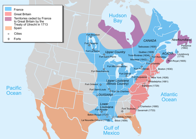
Map of territorial claims in North America by 1750, before the French and Indian War
Image Credit: By Pinpin - https://commons.wikimedia.org/w/index.php?curid=3086036
"The expedition left Catarauqui (now Kingston), crossed to and skirted the south shore of Lake Ontario, until they reached the Genesee river, which they ascended, making one portage around two considerable falls, about a league apart, until they reached its head waters, then after a carrying place of nearly six leagues they reached the head waters of a stream that flowed to the south upon this stream, in a mountain country, they found a settlement called Kanestio, containing several scores of habitations, built of timbers with stone chimneys on the end, outside, and peopled by runaway Frenchmen, Indians out- lawed, who belonged to no tribe; fugitive negro slaves from Chesapeake Bay : renegade Dutch, who had been driven away from Albany, and graceless Yankees from New Ply mouth. A more worthless lot of good-for-nothings, who had no hope of Heaven, or fear of Hell, we never saw. De Villers, after erecting the cross and planting the colors of France, proclaimed that the country belonged to Louis XIV, and was a part of New France. We then hastened away without further ceremony,"
The same authority records that, it was on this journey the good Abbe composed in part that charming work, ” The Adventures of Telemachus,” an allegory representing a youth in pursuit of happiness, guided by wisdom, which will be read while mankind reverence the noble, the beautiful and the true. The fancy that it was in part born in thought, by this murmuring river, makes, indeed, the soil on which we dwell classic ground.
Long before the conquest and fall of New France, both the English provinces of Massachusetts and New York passively claimed this region under conflicting charters. That under which Massachusetts claimed was granted by James I, of England in 1620, and by Charles I in 1628, embraced all of the territory lying between 42 degrees and 44 degrees, 15 minutes north latitude, and extending from the Atlantic Ocean on the east to the Pacific on the west. The province of New York claimed under a charter granted by Charles II, of England, to James, Duke of York and Albany, whereby was granted all of the lands extending – from a line twenty miles easterly of Hudson river, northerly to Canada, southerly to Delaware Bay and westerly to the ocean.
After the conquest and fall of New France, this region was owned by the English, but was occupied by the same Indians as before, who were under the supervision of one of the most remarkable men of that period, who had control of the Indian affairs of the English on this continent Sir William Johnson.
In November 1762, two Indians of Kanestio murdered and confiscated the property of two Dutch traders, English subjects, who were passing through the Seneca country.
At a meeting held by Lieutenant Guy Johnson, deputy agent for Indian affairs, with the Indians at Onondaga, on December 6, 1762, at which, in pursuance of Sir William Johnson’s instructions, and at which the Senecas were notified to attend and produce the guilty parties. Delegations of the Onondagas and Cayugas attended, the Senecas were not represented. Lieut. Johnson then and there said to those in attendance, that if the Indians expected to live in peace with the English, these malefactors must be brought to justice, without unreasonable delay.
Teyawarunte, speaker for the Onondagas, replied as follows:
"Brother, we have all heard and carefully attended to your speech, and must confess the case is very hard both on your part and on ours, as it cannot but give us the greatest uneasiness to think that a village like Kanestio, composed of stragglers from several nations should have presumed to act a part so contrary to the sentiment and inclinations of the confederacy. For our parts we assure you, that we are determined to do everything in our power for procuring you that satisfaction so justly required, but, we are very desirous first to see the Upper Nations, to acquaint them with your speech, and to be informed what they have done in the affairs and we hope their present delay is owing to their being in quest of the murderers. Therefore, we beg you will rest satisfied until the arrival of the Upper Nations, and in case the Senecas do not immediately comply with your demands, you may rest assured we shall, without further delay, go in search of the murderers, being unanimously resolved to pursue them to the utmost distant parts, rather than fail in convincing you how much we disapprove of their barbarity."
The murderers fled to the region of the Ohio river and the Indians declared they could not find them, it was afterwards reported that one of them had been killed.
Sir William Johnson placed no confidence in these reports; he was satisfied that the criminals were being harbored in the vicinity of their depredations, he therefore, in April,1764 sent Capt. Andrew Montour, a half-breed Indian, with one hundred and forty Indians and some white men, to avenge these crimes; he proceeded to Kanisteo, which he completely destroyed. It consisted of sixty good houses, with three and four fireplaces in each of them. He found a large quantity of Indian corn, as also a great number of implements, which they had taken from the inhabitants, with many new saddles, etc., several horses, horned cattle and swine, the most of them in such a poor condition that he killed them all but about a dozen, which they carried with them.
During the war of the Revolution, this territory was transiently occupied by the British and their Indian and Tory allies for the purpose of planning and preparing their murderous invasions upon the patriotic inhabitants and settlements of New York and Pennsylvania.
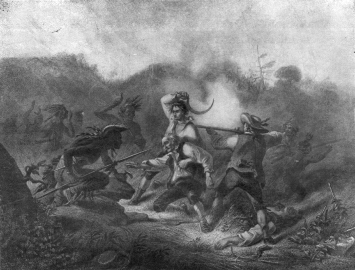
The Wyoming Massacre, photomechanical print from a painting by F.O.C. Darley, c. 1905. Image: Library of Congress, Washington D.C. (Digital file no. cph 3a45741)
The expedition that massacred the inhabitants at Wyoming in 1778, set out from Fort Niagara, by the south shore of Lake Ontario, to the mouth of the Genesee river, thence up that river to where Dansville is now situated, thence over the divide to the Canisteo river – the same route taken by the French before noted – halting at a point now within the town of Hornellsville, nearly westerly of and opposite where Big Creek falls into the Canisteo. Here they built their canoes and floats, with which they descended the river on their bloody errand that culminated in the massacre of Wyoming in 1778. The unsleeping vengeance of the Senecas was avenged for the unlicensed intrusion of the settlers into their sacred valley. It is asserted that the first white settlers in this neighborhood found canoes constructed of the trunks of pine trees, that had been unskillfully made and abandoned, and the tools used in such construction.
Says a local writer of 1812: “Here are still to be seen the marks of the tracks of the invading foe that committed the savage butchery at Wyoming, a fine settlement, and its complete destruction in 1778 will long be remembered. Here the ancient man showeth the stumps of trees from which the canoes were taken, and chilleth the soul with horror at the tale of woe.” A sad memory to associate with the history of the beautiful valley of the Canisteo.
After the American Independence had been acknowledged by Great Britain, at the treaty of Versailles in 1783, and this region had become a part of the United States, the contention between Massachusetts and New York for the right to this territory became sharp and active. Massachusetts claimed under the charters granted by James I and Charles 1.
New York claimed under the charter granted by Charles II, and by reason of the annulment of the Plymouth charter, by the decree of the high court of chancery in 1684, and by the charter granted by William and Mary in 1692, it was contended, all rights granted under the first charters of Massachusetts that in any way conflicted with the claims of New York no longer existed.
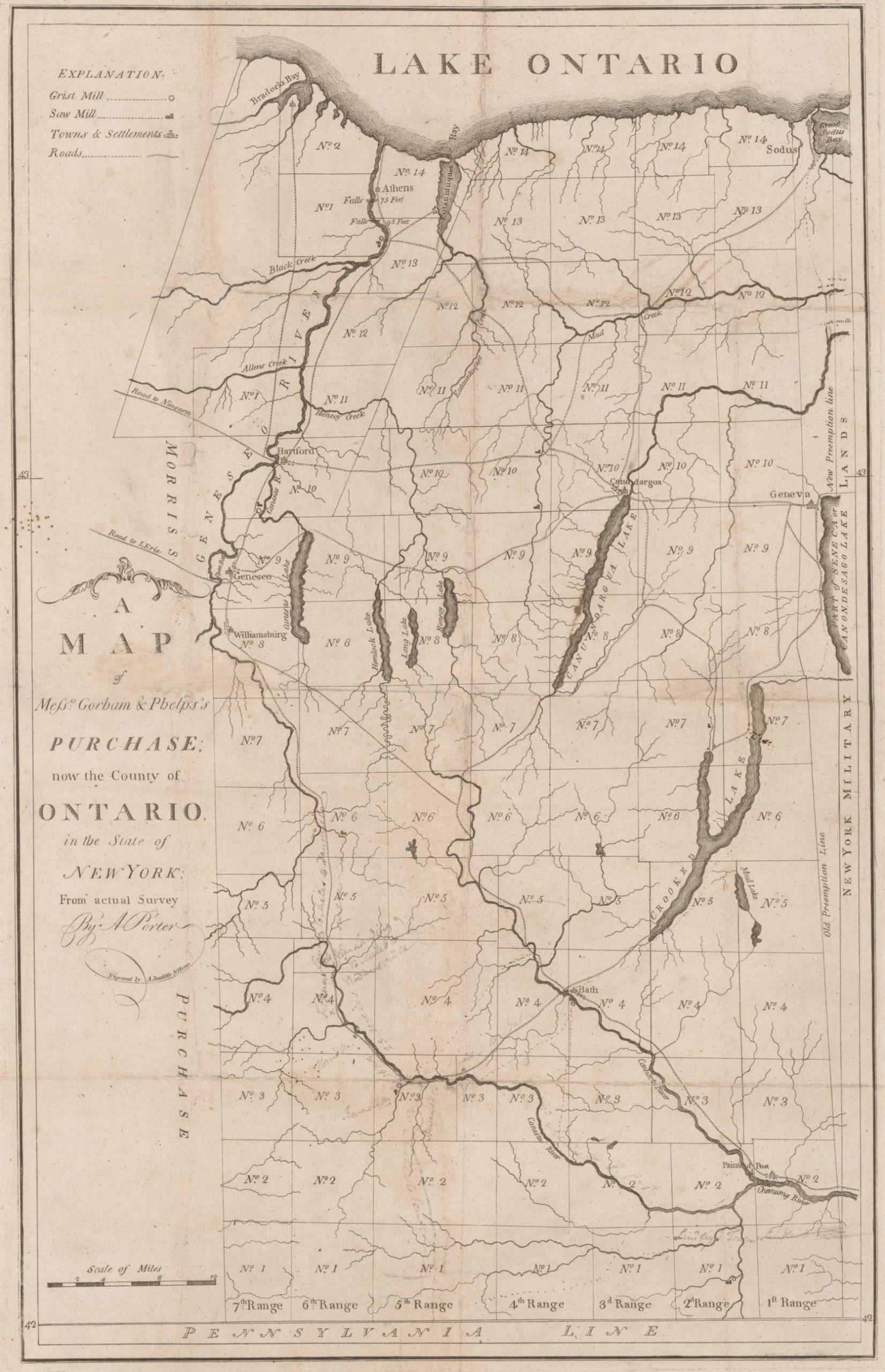
This contention and dispute was compromised by commissioners on the part of each state, four from Massachusetts and six from New York, at Hartford, Connecticut, December 16th, 1786, by Massachusetts ceding to New York the “Government sovereignty and jurisdiction” over the disputed territory and New York ceding to Massachusetts “the right of pre-emption of the soil of the native Indians, and all other estate except of sovereignty and jurisdiction to Massachusetts, its grantees and assigns forever.” These lands comprised about 6,000,000 of acres, commencing at a point in the parallel of 42 degrees north latitude, and in the north boundary line of the State of Pennsylvania, distant 82 miles west from the northeast corner of the State of Pennsylvania on the Delaware river, thence due north to the boundary line between the United States and Canada, thence westerly in said boundary line until it intersects a meridian line one mile east of the confluence of Niagara river with Lake Ontario, and along this meridian line to Lake Erie, then due west to the boundary line between the United States and Great Britain, thence westerly in said boundary line until it intersects with the said 42d parallel, thence easterly along said parallel to the place of beginning. The eastern boundary of these lands commencing at the 82d mile stone and running due north to Lake Ontario, is the celebrated pre-emption line. Its different locations are called the old and new pre-emption lines. The history of the location of these lines is interesting. It discloses the fact that the men of a century ago had an eye to the main chance, that they were fully as alert and unscrupulous as those of the present day.
To establish and locate the new pre-emption line, the theodolite was first used in the United States. It is the meridian of Washington. It forms the eastern boundary of Steuben county.

TWO PRE-EMPTION LINES?
The Old in RED and New in GREEN. Shortly after the original survey of 1788 it was suspected there was an error in this survey. In 1792 a resurvey was commissioned. The new survey revealed defective methods by the first surveyors. Both lines beginning at the correct Pennsylvania boundary stone, was deflected about 2° west of north, hence the wedge shape.
Soon after the close of the Revolution, this region began to attract the attention of adventurers and settlers; pretended leases were made with the Indians to avoid the provisions of the State constitution forbidding a sale by the Indians of the lands then occupied by them.
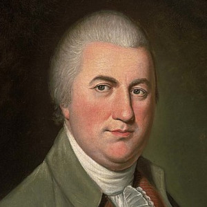
Oliver Phelps
Nathaniel Gorham
In the early part of the Year 1787, Oliver Phelps and Nathaniel Gorham applied to the general court of Massachusetts for the purchase of the right of pre-emption which that commonwealth had in the western territory’ lately ceded by the State of New York, and on the 31st of March, 1788, the commonwealth of Massachusetts, in consideration of £300,000 in consolidated securities of that commonwealth, or £2,000 specie and £290,000 of said securities, sold the right of pre-emption in the before mentioned territories to said Phelps and Gorham. and they were there by authorized to extinguish by purchase, the claims of the native Indians to the soil in the said territory. The Rev. Samuel Kirkland was authorized to superintend and approved the said purchase of Phelps and Gorham from the Indians, on the part of the State of Massachusetts.
Phelps and Gorham, on the 8th of July, 1788, held a treaty with the six nations of Indians at Buffalo Creek, at which, among others, were present Benjamin Franklin and La Fayette, also a young English officer who was present by invitation, and being somewhat of an artist, sketched the scene with so much fidelity that several of the distinguished persons who were present can still be recognized. In consideration of $5,000 and an annuity of $500 forever, they acquired the title of the native Indians in a part of the land ceded by New York to Massachusetts, and described as follows: Bounded on the north by the shore of Lake Ontario, on the south by the aforesaid north line of Pennsylvania, on the east by the pre-emption line, on the west by a line drawn at right angles to the Pennsylvania line, and extending due north to a point of land made by the confluence of the Canaseraga Creek with the Genesee river, thence down the Genesee to a point two miles north of Canawaugus village, thence due west twelve miles, thence northerly and parallel with the Genesee river to Lake Ontario.
This western line of this purchase can now be fixed as follows, beginning at the southwest corner of the town of Independence in Allegany county. forming the westerly boundary of the towns of Independence, Alfred, Almond, Burns, Ossian, Sparta and Groveland, northerly to the confluence of the Canaseraga Creek with the Genesee river, near the point where the D.L.& W. R.R crosses the W.N.Y & P.R.R., north of the village of Mt. Morris, and was long marked by a large elm tree. The village of Canawaugus was near the place where the Attica branch of the N.Y.L.E.A & W.R.R. crosses the Genesee Valley Canal and the Rochester division of the W.N.Y & P. R. R. a few miles west of Avon. The easterly end of the trestle of the L. & P. R. R. over the N. Y. L. E.& W. R. R., near the farm residence of the late Rev. Dr. Lloyd Windsor, in the town of Burns, is on this line.
The State of Massachusetts, on the 21st day of November 1788, confirmed this treaty with the Indians and granted to Phelps and Gorham the land embraced in said treaty within these boundaries were contained, by estimate, 2,600,000 acres of land.
A word as to the consolidated securities with which this land was to be paid for by Phelps and Gorham to the State of Massachusetts. These securities were issued by Massachusetts to help defray her quota of the expense of the war for Independence at the time of the offer of Phelps and Gorham to buy these lands these securities were greatly depreciated in value, and were selling for about 20 per cent., or one-fifth of their nominal value. But by the time that the sale by the Indians had been approved by the general court of Massachusetts, and because of the adoption and ratification of the Federal Constitution, by a majority of the States, a greater feeling of confidence began to prevail through all of the States, of a more perfect and en- during Union, and also because of the requirements of Phelps and Gorham, of a considerable amount of these securities to meet their engagements, they rapidly appreciated in value; were held at par, and in some instances com- manded a premium.
In the spring of 1788, Mr. Phelps left his home in Granville, Mass., to visit the tract he had purchased. It is recorded that the hazard of the enterprise was deemed so great that his family and friends, with the minister of the parish, assembled to witness his departure to the ” far distant country,” and wept over him as one whose return from a wilderness inhabited by savages could scarcely be hoped for.
Because of the inability of Phelps and Gorham to make payments as they became due, on the 18th day of November 1790 and after they had sold several townships of land which were excepted, among which were this town and Canisteo, they conveyed to Robert Morris, of Philadelphia, the great financier of the Revolution, all the remainder of lands they had acquired from Massachusetts and the Indians, or which they were entitled to, for eight pence an acre. Mr. Phelps, who was the principal monied man and the manager of the enterprise, by reason of unfortunate ventures, died an insolvent debtor, on the jail limits in Canandaigua on February 21st, 1809.
Mr. Morris, by deed dated April 11th,1792, conveyed to Charles Williamson for the consideration £75,000 sterling, all of the lands acquired by Phelps and Gorham from the Indians by treaty and last described, excepting sales made by Phelps and Gorham. The lands embraced in that purchase have since been known as the Pulteney estate.
In 1792 and ’93, Mr. Morris after he had acquired the Indian title there to, conveyed and mortgaged to Herman LeRoy, William Willink and others, known as the Holland Land Company, the balance of the territory ceded by New York to Massachusetts and was called the ” Holland Purchase,” except a strip of land two townships wide, extending through the County of Allegany from the Pennsylvania line, northerly to Lake Ontario, an average of twelve miles wide. This is known as the ” Morris Reserve.” This was largely sold under executions issued upon judgments against Mr. Morris.
A large portion was brought by John Church, the father of the late Judge Philip Church, of Angelica, N.Y. Mr. Morris by reason of this purchase became involved in serious financial complications that resulted in his utter ruin and terminated in his death in a debtor’s prison in Philadelphia, Mav 8th, 1808.
It is a melancholy fact. that the purchase of the most fertile part of the State of New York, to-day containing over a million of inhabitants, by Oliver Phelps and later by Robert Morris, should have been the cause of their financial ruin, and consigned both to a debtor’s prison to end their lives.
In the year of 1789, Mr. Phelps opened an office in Canandaigua for the sale of his lands. In the early part of the year, 1789, twelve persons whose names were Uriah Stevens, Sr., Arthur Erwin, Joel Thomas, Solomon Bennet, Elisha Brown. John Jemingson, Uriah Stevens, jr., James Hadley, Wm. Wynekoop, John Stevens, Thomas Bennet and Christian Kress associated themselves together to purchase lands from Phelps and Gorham which they had acquired from Massachusetts. Solomon Bennet and Ellisha Brown, two of these associates, were selected to make the purchase for the benefit of all.
On August 18th 1789 and in pursuance of the purpose, Oliver Phelps, of Canandaigua, Ontario county, N. Y., of the one part, and Solomon Bennet and Elisha Brown, of Chemung, Montgomery Co., N. Y., made an instrument in writing, whereby Phelps agreed to sell and convey to the said Bennet and Brown, two townships of land, each to be six miles long, north and south, and five and a hall miles from east to west, lying in the County of Ontario, State of New York, to be located in such a manner as to take in part or all of the old Canisteo flat, and not to derange the adjacent towns, in consideration of the sum of £2,666, 13s, 4d., lawful money of the State of New York to be paid as follows: One-third on or before May 1st, 1790; one-third on or before May 1st 1791, and the remainder on or before May 1st 1792, with lawful interest. The said Bennet and Brown agreed that before October 1st, 1789, they would give good and sufficient security for the payment of said sum at the times above mentioned and stipulated, and the said Phelps agreed that he would give a good and sufficient deed of the said townships when the said Bennet and Brown shall give the security aforesaid. This was before this tract was run into townships, and the numbers of townships and ranges were not specified. This purchase was approved by the twelve associates, and in September, of the same year, Arthur Erwin, Solomon Bennet, and Joel Thomas were deputed by the associates to go to Canandaigua and complete the purchase. Mr. Phelps being somewhat acquainted with Uriah Stevens, Sr., requested that he should sign the notes for the purchase, which was secured by a lien upon the land and be made a party to the deed, which he did, and a deed was made and delivered from Phelps to these four persons, namely, Uriah Stevens, Sr., Arthur Erwin, Solomon Bennet and Joel Thomas, for township 3, 5th range, and township 3, 6th range. The survey of this tract had then been completed and mapped by Augustus Porter.
It was soon discovered that the Canisteo flats which the company wished to purchase, was not conveyed by this deed which covered the present towns of Canisteo and Hartsville, but that the land they intended to purchase was township 3, 5th range, now the town of Canisteo, and township 4, of the 6th range, now the city and part of the town of Hornellsville. In September 1790 Stevens, Sr., Erwin, Bennet and Joel Thomas went to Canandaigua to get a deed for the last-named townships and to deliver up the first deed. Phelps agreed to give them a new deed if they would strike one-half mile from each township so that each should be 6 by 5 ½ miles, but as some improvement had been made on No. 3 in the 5th range, Canisteo, it was agreed that instead of taking one-half mile from this township, a strip one mile in width be taken from the west side of No. 4 in the 6th range, Hornellsville, so that township 3 should be 6 miles square and township 4 should be 5 miles by 6 and in pursuance of this agreement a deed was made on the 16th day of September, 1790 by Phelps to Uriah Stevens, Sr., Arthur Erwin, Solomon Bennet and Joel Thomas for the same consideration, £2,666, 13s, 4d, payable in the same manner and by the same notes as for the first deed. The security for the payment of the notes was transferred from the first to the last land.
The lands in this deed are described as living in the district of Erwin, in the County of Ontario, State of New York, and known by the name of the old Canisteo Castle.
On October 18th 1789, after the first agreement made with Mr. Phelps by the associates, an agreement was made and entered into in writing between the twelve associates, whereby Uriah Stevens, Jr., Solomon Bennet, Joel Thomas, of Chemung, in the State of New York, and Arthur Erwin, of the State of Pennsylvania, of the one part, and Elisha Brown, Uriah Stevens,Jr., James Hadleyl, William Winekoop, John Stevens, John Jemingson, Thomas Bennet and Christian Kress, of Chemung, aforesaid, of the other part agreed that the party of the first part should let the party of the other part have eight-twelfths of the lands purchased by the first part, of Oliver Phelps, and pay the first part eight-twelfths of the price and cost of purchase, that the first part had incurred, and the party of the first part agreed to convey eight twelfths of said two townships to the party of the other part, when they shall give a good and sufficient security for the payment of said sum.
About this time Augustus Porter, the surveyor of Phelps and Gorham, ascertained that townships 3 and 4 were much larger than supposed. They were about 6 by 8 miles. He accordingly’ cut off from the east side of township No. 3 in the 5th range, 12,099 acres and from the north side of township No. 4 in the 6th range, 9,406 acres. This last cut off is now known as the North Gore. This reduced these townships to the size originally intended.
It may be interesting to those who are unacquainted, to know the boundary and location of township No.4 in the 6th range. Its north line is in the highway leading from Webb’s Crossing, easterly to Miller’s place. This line is five miles in length. Let me say in passing: the point where this line crosses Selah’s Creek, the stream that supplies this city with water, quite near the highway iron bridge at Miller’s, was formerly called Milltown. Here was located and operated a mill, long since abandoned; not a vestige remains, but to preserve this fact this name should be restored to this locality. The west line of No.4 commences at the westerly termination of the said north line, a little north of the McMichael cemetery on Pennsylvania Hill, is the west line of this cemetery lot, crosses the Almond road at the intersection of the road from Webb’s near the residence formerly occupied by Charles Major, now owned by Burdick, and terminates in the north line of Hartsville where it crosses Crosby Creek, near the Hood & Bardeen cheese factory. The east line commences in the easterly termination of the north line, and passes near the dwelling of Ross Swartz. It is the boundary line between the towns of Hornellsville and Canisteo, crossing the N. Y., L. E. & W. R. R., near the proposed Junction with it of that ill-starred conception, the Hornellsville and Pine Creek R. R., and terminating in the south line which is in the line between the towns of Hartsville and Hornellsville.
The title to township 4 in the 6th range, which will henceforth engage my attention, having been vested in four of the associates, and they having given their fellow associates legal evidence of their rights and interests, immediate measures were taken to survey and divide the township into lots and distribute them among the twelve partners.
On the 25th of September, 1790, one hundred years ago to-day, lots were drawn for the ownership of the twelve subdivisions of township 4, at the house of Benjamin Crosby in this township
as follows: Twelve slips of paper were prepared, upon each strip was written the name of only one of the partners, no two of the pieces of paper contained the same name. These slips of paper were put into a hat; seven of the partners were present. All were not in a perfect normal and fit condition for the business on hand, and after some contention it was thought best that neither of the associates should draw in person, so it was agreed that Hannah, wife of Richard Crosby, who was present, should be blind-folded and should draw these slips of paper from the hat, which she did. The first name drawn should be entitled to lot No. 1, and so on, consecutively, until the twelve pieces of paper were drawn. This drawing resulted as follows
No. 1 – James Hadley
No. 2 – John Jemingson
No. 3 – Arthur Erwin
No. 4 – Christian Kress
No. 5 – Joel Thomas
No. 6 – Uriah Stephens, Jr
No. 7 – John Stephens
No. 8 – William Wynekoop
No. 9 – Uriah Stephens, Sr.
No. 10 – Thomas Bennet
No. 11 – Elisha Brown
No. 12 – Solomon Bennet.
An agreement was entered into that day between the owners of these great lots, whereby Arthur Erwin was to survey township No, 4 into twelve lots, of equal width of 133 and ⅓ rods, running the full length of said town from north to south, and each to contain 1600 acres, the most westerly lot was to be No. 1, agreeably to a draft that was made September 13th, 1790 and to deliver a fair draft to every man of his lot that day drawn.
For all of his services, Erwin was to be paid by said owners £47, IOS in money, grain or cattle at market price at Matt Hollenback’s store in Tyouga. One-half of the pay was to be delivered at Newtown Point as soon as the work is done; each man was only to be accountable for the one- twelfth part of the pay. On August 23d,1790, Christian Kress, by a quit claim deed, in consideration of £230 sold all of his interest in townships 3 and 4 tp Arthur Erwin and thereby Erwin became the owner of lot No. 4 in township four, 6th range. John Jemingson was a subscribing witness to this deed. William Wynekoop transferred his interest in this town to Solomon Bennet and he became the owner of lot No. 8. Thomas Bennet transferred his interest in this township to Solomon Bennet and he became the owner of great lot No. 10. Solomon Bennet conveyed this lot to Oliver Phelps, on February 11th, 1794, for the consideration of $1,233.33.
In the summer of 1790, Benjamin Crosby with his family settled in Hornellsville, on great lot No. 8. He erected a house, and lived in it, on the site now occupied by St. James Mercy Hospital, on Canisteo street in the city of Hornellsville. This was the first white man’s house in the city or town of Hornellsville. He purchased this lot of Solomon Bennet, one of the twelve associates, the deed recites that Solomon Bennet, gentleman, conveyed to Benjamin Crosby, yeoman, in consideration of £300, lot No. 8, of township No. 4 in the 6th range of townships, in the district of Erwin, Ontario county, New York, containing 1,600 acres of land.
Benjamin Crosby, the first settler and founder of this city, emigrated from England about the middle of the last century, arriving in New York after a long period of suffering by shipwreck. Richard Crosby, one of his sons, who also settled here with his father, served in the war of the Revolution. He was a captain in General Washington’s body guard. He married Hannah, a daughter of Jeremiah and Anna Baker, and sister of the late Hon. Jeremiah Baker, of Canisteo.
Lot No. 8 is bounded on the west in the city of Hornellsville by Seneca, Canisteo and South Division streets, on the east by a line parallel to the west line which is a little east of Pardee street. We are, and this building, Shattuck opera house, is on lot No. 8.
Oliver Harding came next and settled on the land between Main and Genesee streets, near where Hakes avenue is now located. He was the nearest neighbor of Mr. Crosby. He was a soldier of the Revolution. He afterward moved to Harding Hill, in the town of Fremont. He has grandchildren and great grandchildren now living and in business in this city.
George Hornell came in 1793, he was the son of a Swedish Clergyman, was born in York County, Pennsylvania. He married Martha, a daughter of Uriah Stephens, Sr., the leading man of the twelve associates. Stephens, Sr., had been a soldier in the French war, which terminated in the fall of Canada. He was with Sir Jeffrey Amherst at the capture of Ticonderoga and Fort St. Frederick. He Married Martha Rathbun, a native of Stongington, Conn. He with his sons, Uriah, jr., and John, and his son-in-law, Solomon Bennet, who married his daughter Sarah, were four of the associates, and at the time of the division owned one half of township 4.
On July 9th 1793, John Stephens, who drew great lot No. 7 conveyed this lot containing 1,600 acres to George Hornell. The consideration named in the conveyance was £111. This lot is bounded in this city on the east by Seneca, Canisteo and South Division streets. The west line is parallel with the east line and passes near the east line of St Ann’s cemetery.
Judge Hornell built the first grist mill on the site now occupied by the Thacher mill. It was the first west of Elmira, except one built by Solomon Bennet in Canisteo, which was burned a short time before. Judge Hornell lived in and kept the first inn in the town. It was on the southerly side of Washington street, immediately opposite to Thacher street. He also kept the first store, situated nearby. He represented this county in the Legislature of this state as a Member of Assembly in 1808. He was an Associate Judge of the Court of Common Pleas of Steuben county in 1796.
Judge Hornell died in 1813 and with his wife is buried in the old cemetery in the western part of the city upon the eminence overlooking the valley for miles, up and down the river, and the eastern hills beyond. The disgraceful and abandoned condition of this old cemetery is a standing reproach to those who should protect it. Even the stone that marks the resting place of Hornell and his wife, with its eloquent inscription, is fast disappearing by attacks of vandals who are chipping it away.
Hornell was good man. By his good character and up right conduct he did much to stem the disorder and intemperate conduct that then prevailed in this vicinity. His wife was noted for her deeds of charity and commendable character. She was a ministering angel to all in this valley who were suffering or in want.
Hornell had four sons and five daughters. William was drowned while attending Williams college; George read law and was admitted to the bar; John died in the morning of life, Vincent the youngest child, died at the age of twenty-four. Of the daughters. Patience died at the age of 17; Emily became Mrs. Dr. Walker, and after his death she became the wife of Col. Ira Davenport, the founder of that noble charity, “The Davenport Female Orphan Asylum,” at Bath. Martha was the wife of the late Major Thomas J. Reynolds, of this town; Betsy, Mrs. Augustus Newell, died in Michigan in 1832, and Anne, Mrs. General Hartshorn, and after his death Mrs. Moore, died in 1882.
The records show that George Hornell certified that on November 17th, 1811, “Milo” was born to his slave “Milley.” He afterwards sold the boy Milo to one Hadley, of Canisteo, for $70. After Hornell’s death, Milley ran away to Palmyra. She was returned to Hornellsville. She remained a year or two, when she again ran away, never to return. Milley was the first fugitive slave from this place of which we have any record.
On December 10, 1790, Joel Thomas, one of the associates, conveyed lot No. 2 to Daniel Purdy, 1,600 acres, for the expressed consideration of £110
On September 23, 1794, Solomon Bennet, for the consideration £210, conveyed lot No. 12 of this township, containing 1,600 acres, to John McBurney.
Uriah Stephens, jr., conveyed parts of his lot No. 6, to his sons, John R. and Matt, and to his sons-in-law, Jerathaniel Powers and Bazy Baker and to Stephen Webb and others. Uriah Stephens, Jr., was a man of note in this valley. He held many local offices; in various legal contentions he gave evidence and made depositions concerning the allotment and settlement of this town, which are still preserved in the proper places, In the preparation of this matter I have drawn largely from these records. He died at Canisteo, August 2nd, 1849; he was over 90 years old. Many of his grandchildren are now residents of this city and town.
Arthur Erwin, one of the twelve, died in Pennsylvania in June, 1791, of a gunshot wound, leaving numerous descendants, many of whom are still living in the town that bears his name. He was twice married. He left at his death ten children. His daughter, Sarah, by his first wife, married John Mulhollen. Their daughter Molly, or Mary, became the wife of Thomas McBurney. They died leaving eight children. Sarah married Hon. John Magee, of Bath. She died without children surviving her. Jane became the wife of Thomas J. Magee.
John Jemingson, now Jamison, was born at Dunham, Bucks county, Pennsylvania, December 3, 1753. He was a captain commanding at the battle of Fort Washington, in the Revolutionary war, now the upper part of the city of New York, including Riverside, the resting place of the remains of General Grant. He held the fort until the ammunition was exhausted, when he was taken prisoner, with the loss of 27 men, and imprisoned in the infamous prison ship in New York harbor, where he contracted disease, from which he suffered during his life. He died at Canisteo, March 23, 1836, at the age of 82, on the farm on which he settled in the spring of 1790. He has great grandchildren now living in this city who have filled and are now filling honored and responsible positions. The “white woman,” Mary Jamison, came from the same ancestry.
Solomon Bennet died at Canisteo in October, 1823, aged 73 years. Although at one time holding the largest part (3 shares) of this town, yet by unfortunate ventures and unprofitable investments he died an insolvent. Grandchildren and great grandchildren of Mr. Bennet are now residing in this city.
John Stephens, another of the 12 partners, was a son of Uriah Stephens, the elder, and was known as Col. John. In the latter years of his life he lived in the town of Greenwood, where he died March 19, 1837.
James Hadley died in the town of Canisteo in the fall of 1832, where he had lived since 1789 The remaining five of the 12 associates disposed of their interests in the purchase of these towns; they never became actual settlers.
It will be observed that the territory now embraced in the city of Hornellsville, and all of the town of Hornellsville included in township 4 of the 6th range was not included in the sale to Mr. Williamson, the representative of the Pultney purchase.
We had no interest in the fierce contentions that raged a few years since between the land office and the anti-renters.
This territory was included in Tryon county from March 12, 1772 to April 2, 1784; then in Montgomery county, until January 27,1789 then in Ontario, until the formation of the county of Steuben, March 18, 1796, where it has since remained, notwithstanding the many vigorous but unsuccessful efforts to get out.
It is hoped that it may always remain in Steuben County. It formed a part of the district of Erwin and afterwards a part of the district of Williamson, until 1796, then a part of the town of Canisteo.
A local writer, in the year 1811 in, describing the town of Canisteo says,
“it is nineteen miles long north and south, by fourteen miles wide, its area is 266 square miles. The Canisteo river courses centrally across the town, and is boatable from Arkport to Tioga, in the town of Painted Post. Boats descend the Canisteo laden with one thousand bushels of wheat. The settlements are of recent date, and still retain their first local names. At Hornell's Mills, on the Canisteo, is a ferry and a road of pretty extensive travel; here is located the Canisteo Post office."
On April 1. 1820, a new town was formed and was named by Col. Ira Davenport, who was then a resident, "Hornellsville," for Judge Hornell. It should have been named for Benjamin Crosby.
Col. Davenport came to Hornellsville from Delaware county, N. Y., in 1815, with a wagon load of goods. He became the first merchant here, building with his own hands the store in which he sold his first goods. He remained here about thirty-two years, during which time he was a prosperous trader. He removed to Bath in 1847, where he resided the remainder of his life, contributing largely to its wealth, institutions and advancement, and entirely neglecting the town, village and city, where he laid the foundation for and was aided in accumulating his great wealth and good name. Col. Davenport was born in Columbia county New York, in 1795, he died in 1868.
Warehouses were built on the Canisteo river, near where Main street now crosses it. From these, arks were loaded with grain, potash and other products for shipment to Baltimore. Later on a number of canal boats were built here and floated down the river into the Chemung canal, and from there by way of Seneca and Crooked lakes and connecting canal to Hammondsport, where they were used in canal navigation.
The village of Hornellsville was incorporated under the general village act June 28th, 1852, was reorganized as a village under a special act of the Legislature, and given larger powers April 9th, 1867. The city of Hornellsville was created March 2nd, 1888.
For sixty-two years this was a country crossroads, a rural four corners, with its grist mill, tavern and blacksmith shop.
“It was peopled with a hardy, rough and generally an honest race, who had within them a goodly infusion of that boisterous spirit, and love of rough, and often mischievous play, for which the free and manly sons of the backwoods and frontiers are everywhere famous. The devouring of hominy, hog, venison and all the invigorating diet of a new settlement, the drinking of grog, baiting of bears and wolves, the hewing down of the forest, the paddling of canoes, fighting, wrestling and hunting, all combined to form a generation of yeomen and foresters, daring, manly and free.”
When they went abroad, they made themselves heard and felt, and upon holidays generally, something broke loose. I do not hesitate to say that many who hear me, have some remembrance of these happenings.
For fifteen years it was the ordinary country village; for twenty-one years it was a village of the first class, with all municipal machinery. This was the period of its prosperity and greatest growth. For two years and over it has been a city, and the most populous place in the county.
The school preceded the church in Hornellsville. The first school in the town of Hornellsville was taught by Abagail Hurlbut, in 1796, in what is now the village of Arkport. The first school within the city limits was taught by Miss Sarah Thacher, about 1805, in a block house, then standing opposite the junction of Arkport street with Main street, near the foot of Cemetery hill. The first schoolhouse built within the limits of this city, stood on the south side of Main street, near the head of Pardee street. It was built in 1813. The first teacher was Dudley Miller. Uriah Stephens, Jr., and George Hornell, the younger, were also teachers. The school continued to be a common school until 1873, when, by an act of the Legislature, a graded school and free academy was established.
The first Sunday school was held in a pine grove at Arkport, under the charge of Miss Abagail Hurlbut. In 1799, religious services were held at the house of Judge Hornell by Rev. Robert Logan, an itinerant Presbyterian clergyman.
A Methodist clergyman, the Rev. John Durbin, of Wyoming, Pa., held services within the present city limits, the following year, 1800. He may well be termed the vidette of his church in this valley. He served his Master with the same zeal that the pious Father manifested in the same valley more than a century before. Religious services were held in the log school house on Main street before referred to. The Methodist Episcopal church in this city was organized in 1830. The building has always occupied its present site.
The Presbyterian church was organized July l0th, 1832. In 1843, Rev. Father Benedict Bayer, organized St. Ann’s Roman Catholic church. It is said the first mass within the limits of the town during the present century, at the house of Thomas Doorley, near Webb’s crossing.
The Baptist church was organized October 17th, 1852, by Rev. Thomas Sheardown.
Christs church. Episcopal, was organized into a parish March 6th, 1854, Rev. James A. Robinson was the first rector.
Jewish congregation, Ahavat-Achim, was organized in June, 1867, by Rabbi Israel Erlich.
The First Universalist church, of Hornellsville, was organized May 23, 1868, by Rev. A. G. Clark, of Branchport, N. Y.
The Seventh Day Baptist church of this city was formed April nth., 1877, by Rev. Thomas R. Williams, D. D.
St. Paul’s Evangelical German Lutheran church, August 23d, 1885, by Rev. John Miller, of Port Jervis, N. Y.
The Hornell Library, whose usefulness has been at least next to the church and school, was founded by seven men. I think they were wise, who gave their joint note for $50 for the first lot of books this library ever owned, sold by a noted, liberal and intelligent citizen at a large discount. This library was organized April 6th, 1868. It was the pioneer of its kind in Western New York. It is still in a most flourishing condition and is the pride of the city. No early record of lawyers can be found who were residents in this town. George Hornell, the younger, soon after he was admitted to practice in 1811 abandoned the profession and became a clergyman. He went to what is now the State of Minnesota, where he pursued the last named profession with success.
The first lawyers in town of which I can find any record were John Baldwin, John K. Hale and Nathan Osborn. This was in 1835. The village then had 400 inhabitants. Baldwin noted for his eccentricities, was a man of ability, a master of sarcasm, he died about 1837 at Almond. Hale represented this district in the State Legislature in the Assembly in 849, in the Senate in 1856 and 1857. He afterwards went to Kansas; later he returned to this State; he died in Cortland. N. Y. He is buried in Hope cemetery in this city. He was a man of fine ability and good reputation. Osborn went West and was lost sight of, perhaps someone can tell of his subsequent career. Later, were William M. Hawley; he served in the Legislature of this state, as a Senator, was also the first County Judge of this County under the constitution of 1846. He died in 1869. Robert L. Brund age, who was a district attorney of the county from 1850 to1854, died in 1880. Horace Bemis, who represented the County two terms in the Assembly, died in 1888.
Dr. Augustus Newell was probably the first doctor of medicine to locate here. He moved to Michigan, and died there in 1837. Drs. James Walker, Manning Kelly, Comfort E. Belden, and Samuel Olin were among the early physicians. Among the later physicians were Drs. LumanA. Ward, Charles D. Robinson and Sewell E. Shattuck, all of whom are dead. I suggest to the Medical Society of this city, the propriety of biographical and neurological sketches of the early as well as the later physicians of this town.

The first newspaper, the Hornellsville Tribune, was published November 19, 1851, by Edwin Hough, on the corner of Main and Broad streets. The National American was first published in 1854, by C. M. Harmon; afterwards it became the Canisteo Valley Journal, published by Charles A. Kinney, until shortly after the breaking out of the war of the Rebellion, when it suspended by reason of the enlistment of Kinney in the military service, in which he died. This paper was revived as the democratic vidette by the Burdick brothers, one of whom as the witty but unfortunate ” Sparks.” It then was transformed into the Canisteo Valley Times, and later the Hornellsville Times.
Other newspapers have made their appearance here, and struggled for existence, some of which have survived under other names, but all have been of comparatively recent ventures.
![]() The New York and Erie Railroad was opened to Hornellsville September 1, 1850. Later the Buffalo and New York City railroad was opened from Attica to Hornellsville. It has since become a part of the Erie system, and is now known as the Buffalo Division of the New York, Lake Erie and Western railroad. Hornellsville became and is the terminus of three of the divisions of this system. Since the completion ol these railroads the growth and prosperity of this place has been active and healthy. The thrift of the city is largely due to the prosperity and energy of this railroad.
The New York and Erie Railroad was opened to Hornellsville September 1, 1850. Later the Buffalo and New York City railroad was opened from Attica to Hornellsville. It has since become a part of the Erie system, and is now known as the Buffalo Division of the New York, Lake Erie and Western railroad. Hornellsville became and is the terminus of three of the divisions of this system. Since the completion ol these railroads the growth and prosperity of this place has been active and healthy. The thrift of the city is largely due to the prosperity and energy of this railroad.
Other railroad schemes have been developed and aborted, until the building and completing, within the last three years, of the Rochester, Hornellsville & Lackawanna railroad, by which competing lines of railroads were reached, and placed the city on a more permanent basis for pros- nus and substantial growth.
In 1832, a plot of ground was conveyed to the town for a public park, called Union Park, located at the intersection of Canisteo street with Main street. For a long time after, it was embellished with upturned pine stumps, these were subsequently cleared away, trees were set out and a fence built around it. Years after it was converted into a dumping ground for street refuse. The piles of dirt made it offensive. A local genius conceived the idea of turning it into a cemetery, the bitter sarcasm inscribed upon the head boards placed in the mounds of dirt, so aroused public opinion that it was graded, beautified and adorned with a memorial fountain, to perpetuate the memories of the battles of the Rebellion ot 1861, with flowers and graveled walks, making it the pride of the city, instead of its shame.
The early place of the burial of the dead was on the “knoll” in the western part of the city, now known as the “old cemetery.” Like everything else connected with early Hornellsville, it was neglected and desecrated. It was a ridge of sand, suitable for building purposes, and with the ashes of the forefathers of this valley has been carted away and become a part of nearly every building in the city. Verily the dead we have with us, their remains cement our foundations and are spread upon our walls. This most dis- graceful and barbarous business still continues at a dollar a load.
In 1853 a place of internment was opened a little farther west. Some of the younger and more enterprising of the inhabitants, chagrined and mortified by the neglected condition of the old cemetery, laid out Hope Cemetery, on the site of the new burying ground, procured for it a legal existence and set the machinery of the corporation in motion. It now has graded streets and avenues; fountains, cascades and pools well-kept lots, adorned with beautiful trees, shrubs and flowers. It overlooks a part of the valley of the upper Canisteo, and also the site of the rendezvous and embarkation of the murderous expedition against the settlements in the Wyoming valley in 1778. No place in this State has a more beautiful cemetery.
Of the men of Hornellsville who participated in the War of the Rebellion, I shall not speak; their good record and glorious deeds are preserved in enduring archives. I have brought the events and history of Hornellsville down to the memory of men now living. It is a brief record of events that are rapidly fading away.
The events of the last half century that have occurred in this city should be collected, written up and published t is a subject that ought to command the attention of all our people, those who are passing away, as well as those who are beginning to assume the active duties of life. It should receive intelligent treatment by a competent person. Some son or daughter of Hornellsville, should perform the grateful task.